
I’ve probably said this in every post I write about Glacier National Park, but it quickly became one of my favorite national parks to visit. I think this is partly because of the hike we did: the Highline Trail. As beginner hikers, this hike was no joke. There were parts of it where I didn’t think I’d be able to keep going.
With Austin’s encouragement, we made it through and at the end, we felt amazing! It was such an accomplishment for us.
That said, there are a ton of hikes in Glacier to try. Here are (in my opinion) the best hikes in Glacier National Park:
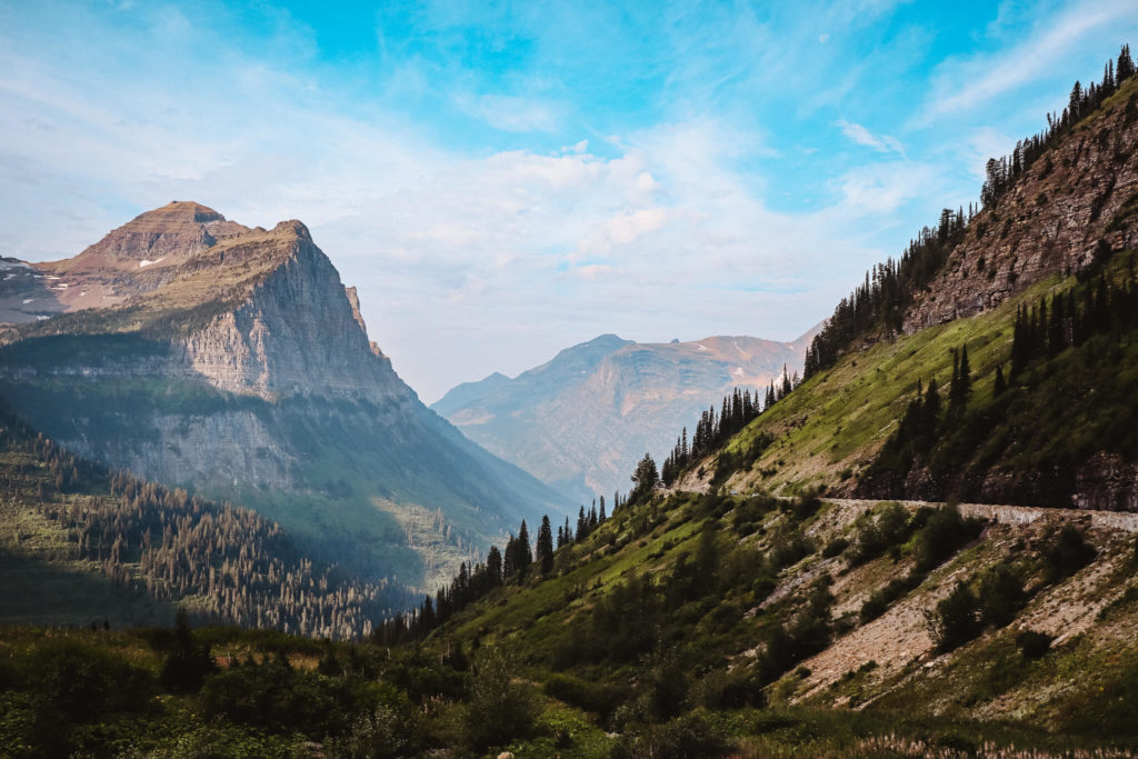
Highline Trail (and Loop trail)
Length: 7.6mi each way (or 11.6mi total by continuing on the Loop Trail)
Elevation Gain: 800ft
Area: Logan Pass (Many Glacier)
I’m not exaggerating in the slightest when I say the Highline Trail changed my life. Austin and I both knew we were doing this trail, so we tried our best to prepare for it by hiking most weekends leading up to it. However, we had never done a hike as long or as strenuous as this one (we are definitely beginners!).
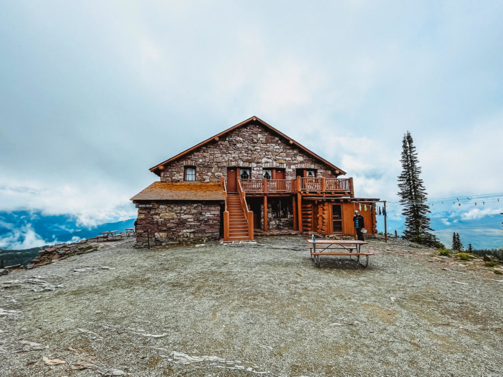
The morning that we were supposed to hike this trail, it was downpouring and about 40 degrees! We waited in the car for a while to see if the rain would let up and it never did. Unfortunately, we couldn’t just do the hike a different day because we were staying overnight at the Granite Park Chalet at the end of the trail that night!
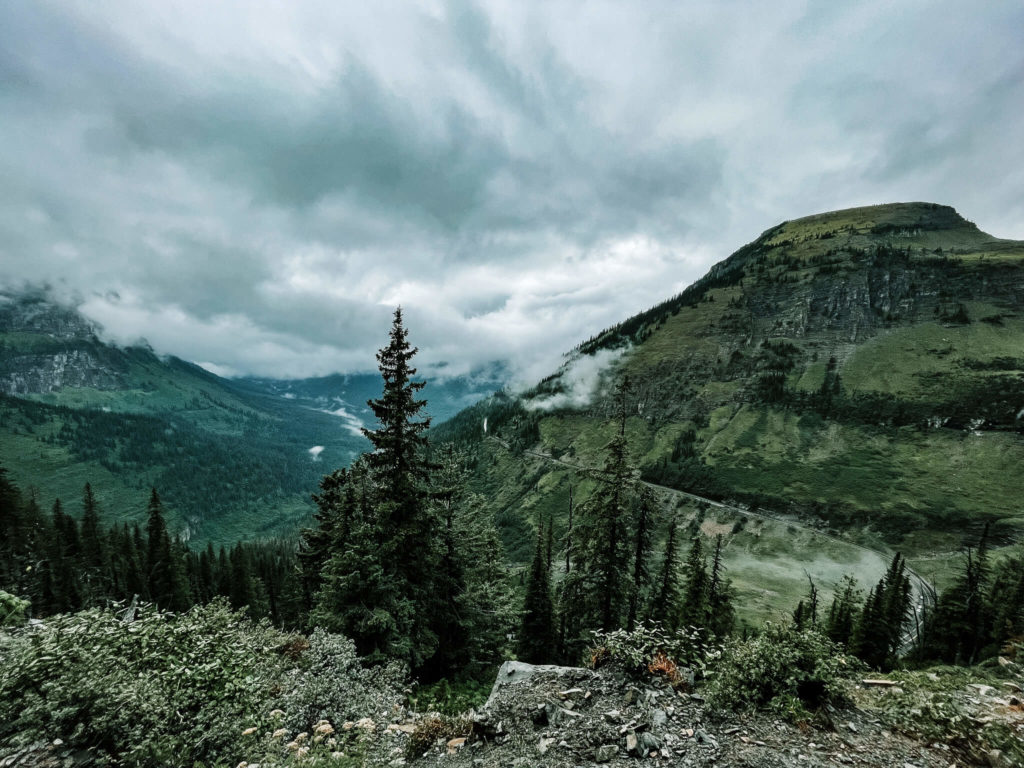
So, we put on our warmest clothes, ponchos, and backpacks and hit the trial in the rain. In hindsight, I actually enjoyed having the fog that came with the cold weather and rain because it blocked a lot of the views when the dropoff was steep. As someone afraid of heights, that was very much appreciated!
I say this hike changed my life because there were parts of it where I genuinely didn’t think I could keep going. Remember, I’m a beginner and I don’t love heights – you’ll probably be fine. However, with a little encouragement from Austin and the knowledge that if we turned around, we wouldn’t have a place to stay that night, I was able to push through and make it to the end.
I showed myself that my body is capable of more than my mind thinks it is.
I learned to trust my body and specifically trust that my feet will go where I put them and stay there. Such a simple concept, but my anxiety kept telling me I’d slip with every step.
I also learned to lean on Austin when it got too hard to handle myself. God bless him.
So, yes, this is one of the best hikes in Glacier National Park for anyone and everyone. It can be done in a day there-and-back. You can also hike the highline trail up to Granite Park Chalet and then take the Loop trail down. There’s a shuttle bus that will take you from the Loop trailhead back to your car at Logan Pass (Highline Trailhead).
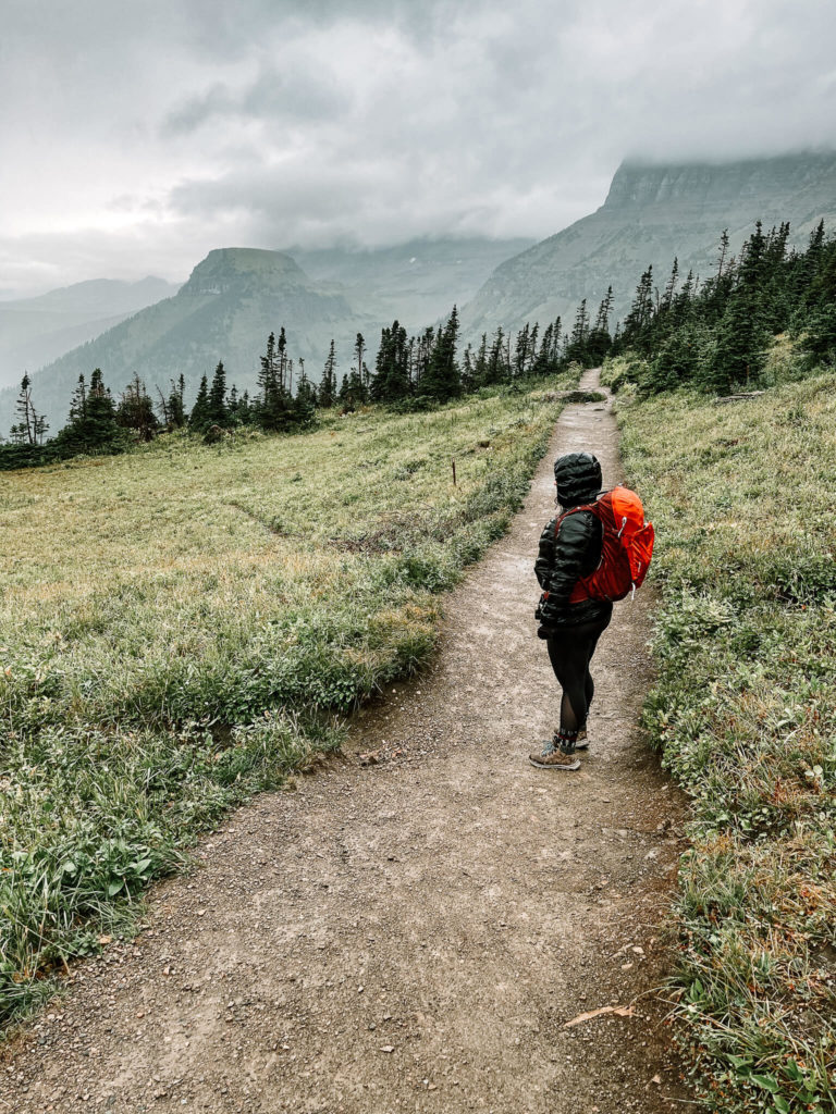
Starting the highline trail 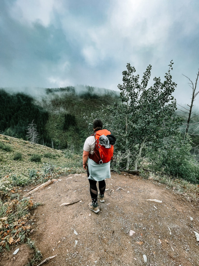
decending on the loop trail
Avalanche Lake Trail
Length: 2.3 miles each way
Elevation gain: 500ft
Area: Near Lake McDonald
If you’ve seen photos of people in Glacier National Park, you’ve probably seen a picture of Avalanche Lake without even knowing it. This trail is relatively short compared to others in the park, so it’s a lot more family-friendly. You’ll start by walking through the Trail of the Cedars which is a wood walking path, and then continue onto Avalanche Lake Trail.
When you get to the end of the hike, you’re rewarded with an amazing view of Avalanche Lake surrounded by mountains. You might even be lucky enough to see an avalanche!
Grinnel Lake/Grinnell Glacier Viewpoint
Length: 3.4mi/5.3mi each way
Elevation gain: 60ft/1,600ft
Area: Many Glacier
There are a few different ways to get to Grinnell Glacier Viewpoint. You can hike the entire trail by starting at Grinnell Glacier Trailhead or Many Glacier Hotel. This is 5.3 miles each way with an elevation gain of 1,600ft. You can also hike to Grinnell Lake from the same starting point which is 3.4 miles with an elevation gain of 60ft (a lot easier!).
The other option is to use the consession boat from Many Glacier Hotel. This cuts the Grinnell Glacier Viewpoint trail down to 3.6 miles and the Grinnell Lake trail down to 1.1 miles. If you choose to use the boat, it is strongly recommended to make reservations with Many Glacier Hotel beforehand.
Swiftcurrent Pass
Length: 6.8mi each way
Elevation gain: 2,300ft
Area: Many Glacier
The Swiftcurrent Pass hike has just about everything you could want when visiting Glacier National Park: outstanding views of mountains, valleys, and glaciers, a high chance of seeing wildlife, and you’re walking past a few very scenic lakes and waterfalls.
This hike is 14.2 miles there and back which means this is more of a day hike. You can definitely spend all day out here by stopping to have lunch by any of the lakes you’ll pass along the way. The highlight (in my opinion) is the view of Swiftcurrent Glacier you get on the trail.
Bowman lake
Length: 7.1mi each way
Elevation gain: rolling hills
Area: North Fork
The Bowman Lake hike is a common option for overnight camping or backpacking. It’s not very strenuous. At the end, you’re greeted with the view of Bowman Lake surrounded by mountains. There is also a campground at this locations which makes it easy to pitch a tent and stay the night!
Rainbow Falls
Length: 1mi each way
Elevation gain: 30ft
Area: Goat Haunt
I wanted to add an easier hike to this list as well. The hike to Rainbow Falls is a short 1mi hike with only 30ft of elevation gain, making it one of the easiest hikes in all of Glacier National Park.
You’ll start at the Goat Haunt Ranger Station and end at Rainbow Falls. Even though this hike is an easier one, it’s beautiful! There are lots of wildflowers along the trail in the summer and who doesn’t love a waterfall?!
Other hikes around Lake McDonald
All milages listed are one-way unless stated it’s a loop.
- Apgar Bike Path: 1.5mi/level
- Apgar Lookout: 3.6mi/1,850ft elevation gain
- Fish Creek Bike Path: 1.2mi/25ft elevation gain
- Fish Lake: 2.7mi/1,000ft elevation gain
- Forest and Fire Nature Trail: 1.1mi loop/180ft elevation gain
- Howe Lake: 1.6mi/240ft elevation gain
- Huckleberry Lookout: 6mi/2,725ft elevation gain
- Johns Lake Loop: 7.4mi/160ft elevation gain
- Lake McDonald West Shore: 7.4mi/level
- Lincoln Lake: 8mi/2,250ft elevation gain
- Mt. Brown Lookout: 5.2mi/4,325ft elevation gain
- Oxbow Trail: 1.5mi/level
- Rocky Point: 1.1mi/85ft elevation gain
- Snyder Lakes: 4.3mi/2,147ft elevation gain
- Sperry Chalet: 6.3mi/3,432ft elevation gain
- Trail of the Cedars: 0.7mi/level
- Trout Lake: 4mi/2,100 elevation gain and drop
Other hikes in Many Glacier
All milages listed are one-way unless stated it’s a loop.
- Apikuni Falls: 1mi/700ft elevation gain
- Craker Lake: 6.4mi/1,400ft elevation gain
- Iceberg Lake: 4.8mi/1,200ft elevation gain
- Piegan Pass: 4.5mi/1,750ft elevation gain
- Poia Lake: 6.4mi/2,400ft elevation gain
- Ptarmigan Falls: 2.7mi/700ft elevation gain
- Ptarmigan Lake: 4.3mi/1,700ft elevation gain
- Ptarmigan Tunnel: 5.3mi/2,300ft elevation gain
- Redrock Falls: 1.8mi/100ft elevation gain
- Swiftcurrent Nature Trail: 2.3mi loop/level
- Hidden Lake Overlook: 1.4mi/460ft elevation gain
Other hikes in North Fork area
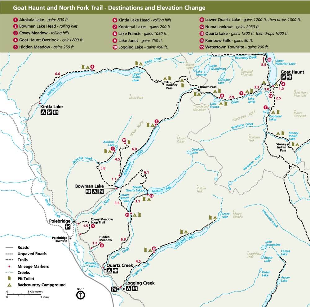
All milages listed are one-way unless stated it’s a loop.
- Akokala Lake: 5.8mi/800ft elevation gain
- Covey Meadow: 1.5mi/rolling hills
- Hidden Meadow: 1.2mi/250ft elevation gain
- Kintla Lake Head: 6.6mi/rolling hills
- Logging Lake: 4.5mi/400ft elevation gain
- Lower Quartz Lake: 3mi/1,200ft elevation gain and 1,000ft drop
- Numa Lookout: 5.6mi/2,930ft elevation gain
- Quartz Lake: 6mi/1,800ft elevation gain and 1,600ft drop
- Goat Haunt Overlook: 1mi/800ft elevation gain
- Kootenai Lakes: 2.5mi/200ft elevation gain
- Lake Francis: 6.2mi/1,050ft elevation gain
- Lake Janet: 3.3mi/level
- Waterton Townsite: 8.5mi/200ft elevation gain
Other hikes in St. Mary
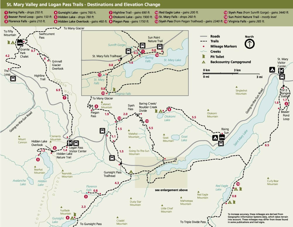
All milages listed are one-way unless stated it’s a loop.
- Baring Falls: 0.3mi/250ft elevation gain
- Beaver Pond Loop: 3.3mi/150ft elevation gain
- Otokomi Lake: 5.5mi/1,900ft elevation gain
- Red Eagle Lake: 8.1mi/200ft elevation gain
- St. Mary Falls: 0.8mi or 1.2mi/260ft elevation loss
- Siyeh Pass: 4.6mi/2,240ft elevation gain
- Sun Point Nature Trail: 0.8mi/250ft elevation loss
- Sunrift Gorge: 200ft/40ft elevation gain
- Virginia Falls: 1.6mi/260ft elevation loss than 285ft gain
Other hikes in Two Medicine
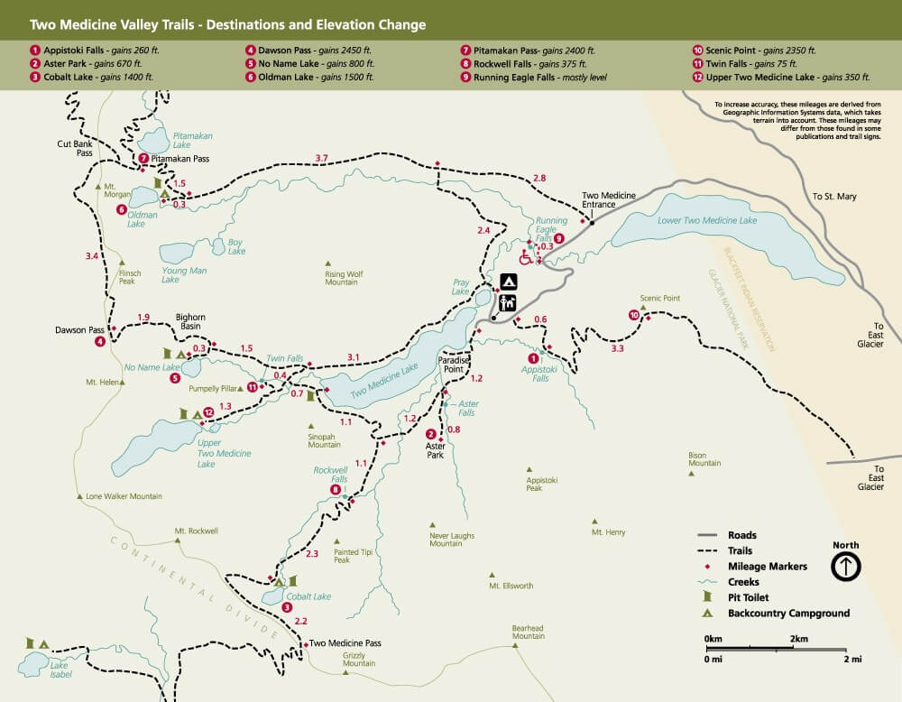
All milages listed are one-way unless stated it’s a loop.
- Appistoki Falls: 0.6mi/260ft elevation gain
- Aster Falls: 1.2mi/100ft elevation gain
- Aster Park: 2mi/670ft elevation gain
- Cobalt Lake: 5.8mi/1,400ft elevation gain
- Dawson Pass: 6.5mi/2,450ft elevation gain
- No Name Lake: 4.9mi/800ft elevation gain
- Oldman Lake: 6.4mi/1,500ft elevation gain
- Paradise Point: 0.7mi/100ft elevation gain
- Pitamakan Pass: 7.6mi/2,400ft elevation gain
- Rockwell Falls: 3.5mi/375ft elevation gain
- Running Eagle Falls: 0.3mi/level
- Scenic Point: 3.9mi/2,350ft elevation gain
- Twin Falls: 3.5mi/75ft elevation gain
- Upper Two Medicine Lake: 5mi/350ft elevation gain
- Medicine Grizzly Lake: 6mi/475ft elevation gain
- Morning Star Lake: 6.6mi/642ft elevation gain
- Triple Divide Pass: 7.2mi/2,380ft elevation gain
- Firebrand Pass: 4.8mi/2,210ft elevation gain
- Scalplock Lookout: 4.7mi/3,079ft elevation gain
Which hikes have you done?
Have you done any of these hikes in Glacier National Park? Which ones were your favorites? Did any of them change your life like the Highline Trail did for me? If so, let me know in the comments!


